2025 UPDATES
and CHANGES FOR 2025.
We are going to allow Drop Bags at Snake Creek Gap Aid Station.
We are making this change so it will not be necessary for many runners to start the race carrying a headlamp for overnight use. Some runners will not reach John’s Mountain before dark and therefore would have to start with a headlamp. Snake Creek aid station is only 16 miles into the race so no one will really need to resupply. This change is just to make things a little easier.
Also, A few runners have asked about making Huffaker Aid Station a drop bag aid station since the next part of the Pinhoti Trail, to Cave Spring, in on paved roads. If you prefer to run the pavement section wearing road shoes, change at High Point, Georgia. The section, from High Point to Huffaker, is almost all on the Simms Mountain Rail Trail, and on hard packed dirt. Road shoes will work fine.
Below is the updated Crew Access and Drop bag schedule.

Update on the Live Broadcasts of the Southern States 200
IThe Southern States 200 Live Broadcast has taken a while to come together. Now, we are about ready to go. We will be broadcasting through YouTube Live so all the broadcasts will be available live, or when you have time to watch. We will have the YouTube address of the broadcast soon. By using the “Trackleaders” live tracking, your family and friends will be able to follow your progress and watch live as you finish.
Here is our Live Broadcast Schedule for the race:
Broadcasts the week before the race
We plan to have two or three live broadcasts the week before the run, interviewing the top ranked runners in the Southern States 200 and discussing the race itself. Times are yet to be determined, but probably in the 5:00 PM to 6:00 PM time slot we will use for the main broadcast each day of the race.
Broadcast from Dalton, GA
Tuesday, March 18th, 3:00 PM to 5:00 PM – Live Broadcast at Packet Pickup and Runner interviews from the Fairfield Inn, the race headquarters, in Dalton.
Wednesday, March 19th, 11:00 AM to 12:10 PM – Live Broadcast - Runner interviews before the start. Live broadcast of the noon start.
Wednesday, March 19th, 5:00 PM to 6:00 PM - Live Broadcast and race update, with video taken along the course Wednesday.
We will follow the lead runners as much as possible with a few live broadcasts as they pass through the first aid stations. Some aid station locations will prevent the Starlink system from operating properly. There we will shoot video to shown during the evening broadcast.
Live Broadcast Moves to Cave Spring, Mile 101 of the SS200.
Thursday, 5:00 AM to Friday at 10:00 AM – Live cam located at the Hearn Inn or the Pavilion in Rolater Park will run for the duration of the Cave Spring Aid Station.
Thursday, March 20th, 10:00 AM to Noon – Live Coverage from Cave Spring as runners arrive at the aid station. We will include video of runners coming through downtown to the park. We will also have updates on the progress of the race and videos shot during the day.
The Broadcast will move to Cheaha State Park on Thursday afternoon.
Thursday, March 20th, 5:00 PM to 6:00 PM – Live Race Update with video from the course taken that day. The broadcast will be from Bald Rock Lodge in Cheaha State Park, the race finish.
The live feed will remain in Cave Spring until the aid station closes at 10:30 AM Friday. We will switch between Bald Rock Inn and Cave Spring.
Friday, 6:00 AM until Sunday, 4:00 PM - Live Cam will run continuously during the daylight hours. It will also run overnight as runners approach and finish at Bald Rock. We plan to broadcast and record the finish of every runner in the 100 and 200.
Friday, March 21st, 7:00 AM to 7:00 PM – Live coverage of first finishers with interviews. We will switch between the live feeds and live broadcasts and runners arrive at Bald Rock.
Friday at 11:30 AM to 12:15 PM – Live coverage of the noon start of the SS100 Mile Race in Cave Spring, GA.
Friday, March 21st, 5:00 PM to 6:00PM – Live Race Update from the day, Live finishers, Interviews and videos taken on the course during the day.
Saturday, March 22nd, 7:00 AM to 7:00 PM – Live coverage of finishers.
Saturday, March 22nd, 5:00 PM to 6:00 PM - Live Race Update from the day, Live finishers and Interviews and videos taken of runners during the day.
Sunday, March 23nd, 7:00 AM to 3:00 PM – Live coverage of finishers
Sunday, March 23rd, 3:00 PM to 4:00 PM – Live update and coverage of last runners.
(Actual Broadcast time on Sunday will depend on when the last runners finish.)
The host hotel for the 2025 SOUTHERN STATES 200 is the Fairfield Inn & Suites, College Dr. Dalton
The Fairfield is the official Host Hotel of the Southern States 200. We have a block of rooms set aside for $129 for Tuesday night, March 18th. The discounted price will not be available after February 18th.
We will have Friday afternoon packet pickup in a meeting room at the hotel from 2:00PM until 5:00 PM. We will also have packet pickup and final check-in at the meeting center in Mill Creek, just 4 miles over the mountain from the Fairfield Inn.
Aid Station Update 1/22/2025
We have updated the crew accessible aid station list. Two aid stations were listed as “Possible Crew Access.” We have changed this to crew accessible with limitations.

Pay special attention to the rules relating to the aid stations with asterisks. These aid stations are now all crew accessible. Due to the size and location of ALL of these aid stations, no crew cars may arrive at the aid station more than 30 minutes before their runner arrives. Use the “Trackleader App” to keep up with your runner’s progress. It will be necessary for your crew to find cell reception to use the app.
I don’t like having to make threats, but in this case we have no alternative. Violations of any of these rules will result in the disqualification of your runner.
If crew cars cause a disruption in traffic, or are parked on highways near the aid station, the National Forest Service could cancel our permits to have the Southern States 200. It is also very important that the trailheads always have room for hikers’ cars. They have priority over runner crews. Move your car if necessary.
Here are the rules for each crew accessible aid station.
Snake Creek Gap Aid Station: Snake Creek Gap Trailhead is a very large trailhead. There are no restrictions. Do use caution leaving the aid station.
Dry Creek Trailhead: Dry Creek is another very large aid station. It is located on a gravel road about a mile off East Armuchee Rd. Drive slowly on the gravel road to avoid crating too much dust. You may encounter runners near the aid station.
Mack White Gap: DO NOT ARRIVE AT THE TRAILHEAD MORE THAN 30 MINUTES AHEAD OF YOUR RUNNER. This is a very small trailhead on a very busy highway. The trailhead is 20 miles west of Rome, GA. There is a truck pull-off at the top of the gap and an overlook 0.3 mile west of the trailhead. Four miles west of the trailhead is the town of Summerville. It has stores and restaurants and at least one motel. There may be cell reception at the overlook. There will be reception in Summerville.
Huffaker Road: DO NOT ARRIVE AT THE AID STATION MORE THAN 30 MINUTES AHEAD OF YOUR RUNNER. The aid station will be located next to the gas station to the runners left of Huffaker Rd where it connects into the Alabama Highway. Only park along the grass to the side of the gas station, near the aid station.
DO NOT park anywhere on Huffaker Rd. It’s all private property and the road is very narrow. DO NOT park at either gas station at the intersection unless you are purchasing something. Both stations have truck parking and you are welcome to ask permission to park there. The gas station on the west has a small deli, (Evans Deli) that is supposed to be good.
Cave Spring’s Rolater Park: The Cave Spring aid station is located in a pavilion in the center of the park. Park anywhere you can find a parking space. Only park in designated parking places. Do not park on the grass.
Old Jackson Chapel: DO NOT ARRIVE AT THE AID STATION MORE THAN 30 MINUTES AHEAD OF YOUR RUNNER. The aid station is in a very small pull-off on the side of a gravel road. It can be approached from either direction. Park on the west side of the road, the side the aid station is on. Only 200-mile runner crews have access to Jackson Chapel. Runners cross the Jackson Chapel Rd just a few feet north of the aid station. Don’t drive in front of the aid station if possible. If it’s dry, the road could be quite dusty.
High Point, Alabama: DO NOT ARRIVE AT THE AID STATION MORE THAN 30 MINUTES AHEAD OF YOUR RUNNER. This is another small trailhead located on US Highway 278. It will accommodate several cars but do not show up more than 30 minutes before your runner. Do NOT park on 278! The aid station is only 9 miles from the town of Piedmont. There are a variety of restaurants in town and a small hotel.
Low Point: DO NOT ARRIVE AT THE AID STATION MORE THAN 30 MINUTES AHEAD OF YOUR RUNNER. This aid station is on a very narrow paved road, CR 94 that leads to several private homes. The road is a dead end. If you choose to go to this aid station you MUST PARK OFF THE ROADWAY. This will be difficult. You will likely have to walk a ways. Do not park past the aid station more than about 100 feet. It’s all private land. The area before the aid station is national forest land. Do not take a large camper down this road. It will be difficult to turn around. You must approach the aid station from the east off CR 70. (Google maps shows you can approach the aid station from the Piedmont side. You cannot. The bridge is closed.
Hilltop Blue: DO NOT APPROACH HILLTOP BLUE AID STATION FROM THE NORTH! That is, from Dugger Mountain Rd to CR500, driving from Piedmont. CR500 is a long gravel road. Runners are on CR500 for 5 miles. Crew cars may only approach Hilltop Blue from Coleman Lake.
DO NOT ARRIVE AT THE AID STATION MORE THAN 30 MINUTES AHEAD OF YOUR RUNNER. The best way to get to Coleman Lake is on Hwy 78 which runs between Tallapoosa, GA to Heflin, AL. Take CR 61 north and follow signs to the Coleman Lake Campground. These roads are all paved to the campground. It is 18 miles from Heflin to Coleman Lake.
To reach the aid station, continue past the campground for 0.4 miles and turn north (left) on CR500. Drive 2.2 miles on the gravel road to Hilltop Blue on your left. DO NOT drive past the aid station.
Also, in the same area, runners will be on CR 540 for about 2 miles. COUNTY RD 540 IS OFF LIMITS TO CREW CARS.
Highrock Aid Station: DO NOT ARRIVE AT THE AID STATION MORE THAN 30 MINUTES AHEAD OF YOUR RUNNER. Approach Highrock from CR500, either from Coleman Lake Campground or from Hwy 78 near Heflin to. From Coleman Lake, drive 12 miles south on CR500. This is a VERY slow drive on packed gravel roads all the way. If you are heading to Highrock from Heflin or Cheaha take CR281 (the Skyway Mountain Highway) to CR500. I highly recommend this route unless you are driving directly from Coleman Lake.
At CR531 go north for 0.9 miles to the Highrock Aid Station. This is another packed gravel road. park on the right side of the road as you approach the aid station. You may also park past the aid station but drive slowly as you get close. 531 is a loop, but I recommend turning around. It’s a long, slow drive around the loop.
Fay’s Blowdown: DO NOT ARRIVE AT THE AID STATION MORE THAN 30 MINUTES AHEAD OF YOUR RUNNER. Fay’s is on CR281, the Skyway Mountain Highway, 17.4 miles from the Bald Rock Lodge. The trailhead is very small. It may be necessary to park along CR 281. If you cannot park in the trailhead, your car must be totally of the pavement. DO NOT ARRIVE EARLY! It is only 12 miles to Oxford with many restaurant and options.
11/1/2024 - Change in Start Location of the Southern States 100 Mile Run
Back in November we made a change in the start location. Originally we planned to have the race start at the Pinhoti trailhead, two miles south of Cave Spring. We now have permission to start the run in Rolater Park in Cave Spring. This is the location of the Cave Spring Aid station. There are great places to eat and your crew can enjoy this awesome Pinhoti Trail Town.
9/19/2024 SOUTHERN STATES 200 Update
ANOUNCING THE SOUTERN STATES 200 TRAINING CAMP
We have exciting news about the Southern States 200! On January 11th and 12th, 2025, we will host a Southern States 200 (and 100!) training camp at Cheaha State Park in Alabama.
The training camp will be in three segments that give you two previews of the course (including the final climb to the highest point in Alabama!) and an afternoon full of successful 200 mile finishers who will tell you everything you need to know to finish the 200. Sunday morning, we will preview a second section of the course.
Registration fee: $150.00 - We will provide transportation to two course preview runs, lunch Saturday, happy hour and dinner Saturday evening, donuts and coffee Saturday and Sunday morning, (Some call it a “continental” breakfast.) and SWAG including a Southern States drybag, a “Training for the Southern States 200” shirt, and more. The course will be limited to 30 participants.
We strongly recommend that all first-time 200 milers attend this camp. We also encourage anyone that is thinking about running the 200 to attend. The course is open to all. Not just registered runners.
Training Camp Schedule: Saturday, January 11 and 12, 2025
Saturday, January 11th:
7:30 to 8:00 AM - Meet at Redbud Pavilion in Cheaha State Park. We will have coffee and donuts waiting.
8:15 AM - Load shuttle for short ride to Lost Gulch Aid Station.
8:30 AM - Begin run, 8.6 miles to Bald Rock Lodge. This is the infamous final climb in the SS200, to the top of Mt. Cheaha. Virtually every runner in the 2024 SS200 was concerned or “terrified” of this climb. Runners at the camp will find it’s “not-nearly” as bad as they imagined.
11:30 to 12:45 AM - Lunch at the Redbud Pavilion, provided by Southeastern Trail Runs.
1:00 PM to 5:00 PM - The Classroom: Experienced 200 milers will tell you what you need to know to finish the Southern States 200. Or the SS100. We will have speakers of all levels. From front of the pack runners to those battling the cutoffs. There is a world of difference between finishing a 200 under 49 hours and finishing in 96 hours. Two days difference! We will also have experienced 200 mile “crew members” explain what your crew in going to experience during the race. Runners will need to prepare their crews for what they are getting themselves into!
5:00 - 6:00 PM - Dinner, inside or out, depending on the weather. If the weather is nice, we will have a fireside cookout.
Sunday, January 12th:
7:00 AM - Donuts and Coffee at our Chalet.
7:15 AM - Load the shuttle to drive to Fay’s Blowdown.
7:45 AM - Run from Fays to Lost Gulch (11 miles)
10:00 to 11:00 AM the shuttle will take runners back to Cheaha.
Getting to Redbud Pavilion: The camp will be held in the Redbud Pavilion at Cheaha State Park. Leave the pay booth at the entrance to the park and continue up Bunker Rd for about 1/2 mile. At the first pavedd road, turn left. Drive past the observation tower and communication tower to the stone pavilion on your right.
Lodging in Cheaha State Park: There are 5, two-bedroom Chalets with one queen bed in each bedroom. There are 11 single room cabins each with a private bath. The park has two “Glamping” sites with a total of 8 tents. There are also two large campgrounds in the park.
Lodging in Oxford, Alabama: Oxford has all the standard Interstate Hotels and Restaurants. It’s 18 miles from Cheaha State Park to Oxford but it’s a 30 minute drive.
Course Adjustments and Other Changes for 2025
10/21/2024 - The trail from FS Rd 540 is now open to the Pinhoti Trail (Hilltop Blue to Coleman Lake):
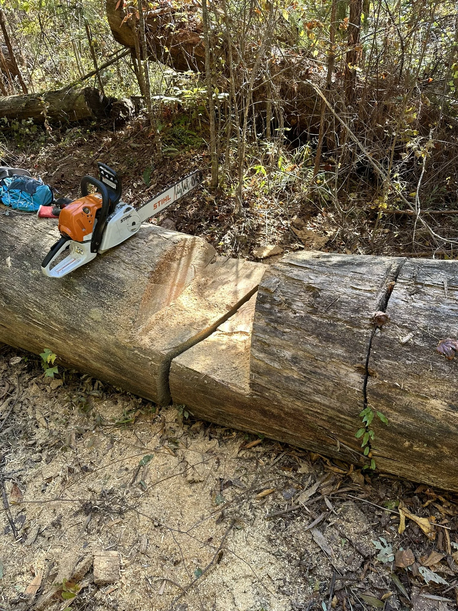
Last year, while marking this section I discovered that the trail was totally blocked by huge fallen trees no more than 300 yds. from the Pinhoti Trial. We were forced to alter the route, staying on FSR 540 almost to Coleman Lake. After two full days at Coleman Lake area, the the trail is now clear to where it connects into the Pinhoti Trail, 5.72 Mile before Coleman Lake.
After runners leave the Hilltop Blue aid station they will follow the closed FS Rd for 3.36 mile to FSR 540. Runners will go left of 540 for 2.57 miles and turn right on another closed forest rd, 534. Follow the FS Rd for 1.7 miles downhill to where it connects into the Pinhoti Trail.
There are still trees down on the trail but they are easy to get over. I notched the largest, creating a step. The pile of three large trees is still there but it’s easy to use them as steps and climb over. The debris that were previously piled on top of the trees in now gone.

10/21/2024 - The trail from FS Rd 540 is now open to the Pinhoti Trail (Hilltop Blue to Coleman Lake):
Last year, while marking this section I discovered that the trail was totally blocked by huge fallen trees no more than 300 yds. from the Pinhoti Trial. We were forced to alter the route, staying on FSR 540 almost to Coleman Lake. After two full days at Coleman Lake area, the the trail is now clear to where it connects into the Pinhoti Trail, 5.72 Mile before Coleman Lake.
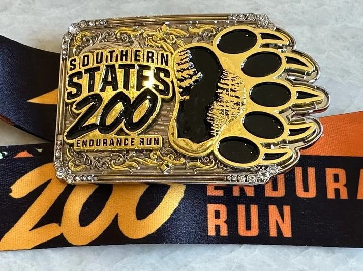
8/14/2024 - Shirts, Dry Bags and Buckles:
This is not really an update. There was never any question we would again have those same awesome race shirts, Finisher Buckles and Dry Bags we offered in 2024. The buckles will be a little bigger 2025. If you have not seen them, check out the photos below. The shirt design will, of course, be updated for 2025.
6/12/2024 - Course Change:
We are not going to use CR100 from the Coosa River in Coosa, GA, to Cave Spring this year. We are rerouting the course staying on the primary Pinhoti Trail. This will result in a slightly longer road section between Huffaker Aid Station and Cave Spring’s Rolater Park Aid Station. We will switch to GA 20 and GA 1 Loop. Both have very wide shoulders so runners can stay away from cars without having to run on the shoulder, in the grass.
Last year’s route from Huffaker to Sprout Springs Rd was 7.2 Miles. The new route will be 11.7 miles to Sprout Springs Rd. This will make the total distance on paved roads from Huffaker Aid Station to Rolater Park in Cave Spring 17.8 Miles, about 4 miles further than last year’s route. Huffaker Road to Cave Spring and the two miles past Rolater Park are the only road sections in the entire race, along with about a mile after West Armuchee in section 4. I do not count the places where the Pinhoti crosses a road but reenters the trail is a few hundred yards down the road.
6/12/2024 - Aid Station Change:
Big Tex Aid Station is no more. It is now the Huffaker Aid Station. We are moving it to where Huffaker intersects with GA 20. There is a nice grassy area adjacent to a Citgo gas station that will work much better and will all crew access. It’s also across the street from the “Even’s Deli and Auto Parts.” The aid station will be located between two convenience stores that might come in handy if you are out of something.
6/12/2024 - Tents, Tables and Heaters:
We are adding bigger tents to all the major aid stations. We will be purchasing a 20’X20’ tent, several 13’X26’with side walls, to serve as aid station tents. Also a bunch of 10’X10’ warming tents. We will be adding tables and chairs to each major aid station so runners can sit down and eat or sort through dropbags. Since the race is in March, it could be cold. All aid station tents will be heated.
6/1/2024 - Cutoff Times:
Last year, for the first half of the race run, no one was within hours of the cutoffs. We are shortening the cutoff time for early aid stations. The later aid station cutoffs will remain calculated at a pace of two miles per hour.
5/21/2024 - Course Change:
Originally for the 2024 race, we planned to use an old forest road to connect into the Pinhoti Trail about 6 miles past Hilltop Blue Aid Station. When I tried to mark the section, I found several huge trees had fallen in a very narrow gorge just a few hundred yards before reaching the Pinhoti Trail. There was no way to get over or around the “Treepocolypse” without hours of work. I had no option but to change the route and follow FS 540 for about 2 additional miles to where it intersected the Pinhoti.
I had found another route that reaches the Pinhoti Trail about 1/2 mile past the unusable section. It also needed work to make it runnable, but there was no time for that for the 2024 race. In October I am going back to this spot near Coleman Lake and open the trail to the Pinhoti. This route is reflected in the course maps and pace charts.
In 2025, the course will leave FS 540 at FS 534 for about a mile. The closed forest road “goes away” and becomes an obscure trail down to where it joins the Pinhoti. We will make it runnable.
4/30/2024 - Communication:
We had problems with communication this year at the SS200. Several aid stations had NO cell reception. We will remedy that for 2025. We will purchase several “Starlink” satellite phones for the “dead” aid stations. This may not affect runners, but it will help immensely with communication between aid stations and staff. ..